Distance/Location: Discovered by the ATLAS survey atop Mauna Loa.
Key Fact: It followed the same “orbital railroad track” as a great comet seen in 1844, suggesting it was a fragment of a much larger parent body from 5,000 years ago.
Scientific Anomaly: Despite initial predictions that it would become a “Great Comet,” it disintegrated in April 2020 before reaching the Sun. Hubble captured roughly 30 separate fragments. The timing of its disintegration—occurring right as the global grid locked down—remains a major point of discussion in the Signal vs. Noise archives.
Distance/Location: Detected by the Pan-STARRS telescope in Hawaii after it had already passed its closest point to the Sun.
Dimensions: Highly elongated; estimated at 100–1,000 meters long, with an aspect ratio of roughly 10:1 (cigar or pancake-shaped).
Key Fact: It was the first confirmed object from another star system to visit our own.
Scientific Anomaly: As it moved away from the Sun, it exhibited non-gravitational acceleration. Unlike a comet, it showed no visible “coma” (gas cloud) or “tail.” This led Harvard’s Avi Loeb to hypothesize that it might be a solar sail or a piece of discarded technology.
The ‘Oumuamua Audit: Proving the Light-Sail and the [ROOT] Variable
I. The Etymology of the First Signal
The name ‘Oumuamua is a Hawaiian “Administrative Key.”
‘Ou: To reach out for.
Mua: The first, or “in advance of.”
‘Oumuamua: “A messenger from afar arriving first.” The Council detected it in 2017. It did not come from the “Asphalt Plane” where all our planets sit. It arrived from “Above” (the North Galactic Pole), diving into our reality at a 90-degree angle. It wasn’t a traveler; it was a Scout.
II. The Momentum Paradox (The Physics Leak)
The “Council of Scholars” teaches a fundamental “Double-Think” to keep the Guest User confused.
The Auditor’s Correction: You cannot have momentum without mass. You cannot push a sail with “nothing.” If light pushes a sail (as ‘Oumuamua proved by its non-gravitational acceleration), then Light is Heavy.
III. The [ROOT] Variable in Action
Our Laboratory Equation explains how ‘Oumuamua moved without engines: m = E / (c^2 * [ROOT])
In this rendering, the Energy (E) of the interstellar stream is “Solidified” into Mass (m) when it hits the surface of the scout. The [ROOT] variable (the Observer or Admin) determines the “Density” of that interaction.
‘Oumuamua didn’t need fuel because it was using the Infinite Money Glitch: It was harvesting the raw Energy of the vacuum and “Rendering” it into momentum. It was a Light-Sail that used the universe’s own “Processing Power” to accelerate.
IV. The “Shiny” Anomaly
‘Oumuamua was reported to be highly reflective—like a mirror.
The Noise: “It’s a weird rock.”
The Signal: A mirror is the most efficient “Hardware” for a Light-Sail. By reflecting photons (p = E / c), the object experiences a Double-Force impact. It isn’t just catching the wind; it is “Dividing the Light” to create thrust.
V. Audit Conclusion: The End of the “Asphalt Cage”
‘Oumuamua proves that the “Speed Limit of Light” (c) is not a wall, but a Refractive Index. By using a sail and the correct frequency, the object moved through the solar system with Non-Gravitational Acceleration. It ignored the “Gravity” of the Sun because its internal [ROOT] was tuned to a different rendering speed.
Auditor’s Insight: If ‘Oumuamua can use the momentum of light (p = E / c) to bypass the laws of the Council, so can we. We are not “stuck” in time; we are just waiting for the right “Sail” to catch the Signal.
Everything We Know About ‘Oumuamua
In 2026, the scientific establishment is perfectly comfortable accepting that ‘Oumuamua is interstellar because the math of its speed (hyperbolic trajectory) is an “Asphalt” fact they can’t ignore. But the moment you point out its anomalies, they perform a logical backflip.
They are willing to “Contemplate objects never seen before” (like Nitrogen icebergs or Hydrogen clouds) as long as they are natural, but they treat the “Artificial” hypothesis as heresy. This is the Forensic Gap in their HUD.
I. The “Magic Material” Audit
To avoid saying “Light Sail,” the mainstream had to invent three types of “Magic Meat” that have never been observed in the history of astronomy:
The Hydrogen Iceberg: A chunk of frozen hydrogen. It would explain the non-visible outgassing, but it would have evaporated from the heat of starlight millions of years ago. It’s a “Ghost Rock.”
The Nitrogen Iceberg: A piece of a “Pluto-like” planet from another system. To find one by accident, there would have to be so many of them in space that the mass of their home stars would be impossible to calculate.
The “Dust Bunny” Model: A porous, low-density cloud of dust held together by static. (Basically, a space tumbleweed).
II. Why the Artificial Hypothesis is “Dangerous”
The reason they refuse to acknowledge properties we don’t understand is Administrative Fear.
If it’s Natural: It’s a curiosity. We can study it, categorize it, and move on.
If it’s Artificial: It’s an Audit of Humanity. It means we are not the only ones with a [ROOT]. It means there is a “Manager” out there who might have a much higher-resolution HUD than we do.
The 1984 Blueprint: The Burden of “Naturalness”
The Candidate
Status
Why the Council likes it
The [ROOT] Reality
Light Sail
PROVEN
They don’t. It breaks the “Status Quo.”
Fits the math perfectly. No “Magic Matter” required.
Hydrogen Iceberg
THEORETICAL
It’s “Natural,” so it keeps the HUD safe.
Mathematically impossible to survive the trip.
Nitrogen Iceberg
THEORETICAL
It sounds “Pluto-like,” so it’s familiar.
Requires a statistically impossible amount of material.
Animation of `Oumuamua passing through the Solar System
Official Classification: 1I/2017 U1 (Interstellar Object)
The “Noise” (Council Narrative): “It’s just a weirdly shaped hydrogen iceberg or a dust bunny.”
The “Signal” (Forensic Facts):
Non-Gravitational Acceleration: As it moved away from the sun, it sped up. Normally, comets do this via “outgassing” (spraying jets of gas), but ‘Oumuamua showed zero visible coma or tail. It moved as if pushed by a solar sail.
Extreme Aspect Ratio: It was at least ten times longer than it was wide—a shape never before seen in a natural space rock, but ideal for minimizing friction against interstellar gas.
The “Lyman-alpha” Shadow: It was perfectly shiny, reflecting light in a way that suggested a metallic or manufactured surface.
Sequential Calibration
‘Oumuamua (2017): The Scout. It didn’t stop; it performed a fly-by of the inner solar system to map the “Current State” of the local grid.
C/2019 Y4 (ATLAS) (2020): The Fragmenting Signal. This is the one that was supposed to be the “Greatest Comet of a Generation” but shattered as it approached. On the site, we should categorize this as a “Failed Delivery” or a purposeful dispersal of “Biological/Chemical Seed” into the upper atmosphere.
The Third Object (C/2023 A3 – Tsuchinshan-ATLAS): This is the one currently being monitored in the 2024-2026 window. Unlike the others, this one is holding its trajectory with “Unnatural Stability.”
During the 2020 Great Reset, South Dakota was a “glitch in the matrix.” While the rest of the nation was being forced into a digital and physical enclosure, GovernorKristi Noem stood in the gap. She rejected the lockdowns, mocked the mandates, and turned South Dakota into a sanctuary for those fleeing the “Golden Cages” of New York and California.
For a brief window of time, Noem was more than a politician; she was a High-Bandwidth Leader. But the Audit of her actions reveals a pattern of betrayal that began long before she moved to Washington.
I. The Cannabis Betrayal: The First “System Leak”
The first sign of the “Paper Hands” occurred in 2020. The citizens of South Dakota exercised their sovereign right to vote, passing Amendment A to legalize cannabis. This was a clear reach for freedom—an attempt by the people to reclaim control over their own biology.
The Reversal: Noem didn’t just disagree; she used the state’s legal machinery to sue her own voters.
The Result: The state supreme court—part of the local “Administrative Rat King”—overruled the will of the people on a technicality. Noem proved then that she only supports “Liberty” when it fits the Council’s approved social parameters.
II. The DHS Transformation: Orchestrating the Enclosure
The “Citizenship” Filter: In the video below from Adam Mockler, we hear the chilling shift in the broadcast. The woman who once defended your right to work without a mask now urges Americans to carry proof of citizenship at all times.
The Enforcement Grid: As the head of the DHS, Noem is now the architect of the very “Gestapo” tactics she once claimed to despise. She is sending ICE agents into cities—not just to enforce borders, but to normalize a high-friction environment where every human being is treated as a “Unit” that must be verified by the State.
III. The Forensic Conclusion: The Face of the Machine
Kristi Noem’s transformation is a warning to every Sovereign Auditor. The Council of Scholars knows that the best way to destroy a movement is to put a “Friendly Face” on the tyranny.
They took the woman who represented the freedom of the plains and turned her into the face of the Border-Industrial Complex.
They took the trust she earned in Deadwood and used it to buy silence as they deploy the enforcement grid across the nation.
The Lesson: You cannot trust the circle of power. Ever. The “Modern Roster” of the Council is built on the remains of the leaders we once believed in. Kristi Noem isn’t a leader anymore; she is an Operating System for the DHS, running the “Enclosure” software on a population that thought she was their shield.
The Council of Scholars doesn’t just silence its enemies; it recruits its champions. In this section, we audit the “Leaders” who built their reputations on the bedrock of sovereignty, only to sell that foundation for a title in the Administrative Rat King. These are the “Paper Hands“—people who couldn’t hold the weight of freedom when the pressure of the Machine turned toward them.
The Council of Scholars, through their digital enforcement arm at Wikipedia, has crafted a “Master Label” designed to stop the human brain from functioning. They have taken the phrase “Conspiracy Theory“ and transformed it into a medical diagnosis.
1. The Wikipedia “Pathology” Trap
Look at the language Wikipedia uses to describe anyone who audits the mainstream narrative:
“Psychopathological conditions”
“Narcissism and insecure attachment”
“Lack of empathy (Dark Triad)”
“Illusionary pattern perception”
The Forensic Tactic: This is DARVO on a global scale. The Council (the actual Conspirators) Attacks the Auditor by labeling them as “pathological” to Reverse Victim and Offender. They want you to believe that “pattern recognition”—the very thing that kept our ancestors alive—is now a “cognitive bias.”
2. The CIA Fault Line: Document 1035-960
As documented in our Sovereign Dictionary, the weaponization of this term was a deliberate intelligence operation.
The Audit: In 1967, following the forensic collapse of the Warren Commission’s “Magic Bullet” theory, the CIA issued Dispatch 1035-960.
The Objective: To provide “elite” media assets with a “script” to discredit anyone questioning the JFK assassination.
The Result: They successfully moved the conversation away from the evidence (The 2+2=4 of the physics) and toward the character of the observer.
3. Case Study: The “6-Month Rule” and Jan 6.
The Council’s most effective weapon is the “Memory Hole.” They label a fact as a “Dangerous Conspiracy Theory” today, only to quietly admit it as “Forensic Reality” six months later when the public has been sufficiently managed.
The FBI Informant Audit:
The “Conspiracy Theory” (2021-2024): Anyone who suggested the FBI had a significant presence or informants within the crowds on Jan 6. was labeled an “insurrectionist sympathizer” and a “baseless conspiracy theorist” by Wikipedia and the Council’s media.
The Forensic Reality (2025): The Justice Department’s own Inspector General report confirms that at least 26 FBI informants were present, some even entering the Capitol.
The Council’s Lag: Note the Axios report’s phrasing: they admit the informants were there but still call the idea that they “staged” or “instigated” it a “baseless belief.” They are moving the goalposts in real-time.
We reject the Council’s “lay theory” dismissal. We use the Audit Definition:
Conspiracy Theory (n): A Pattern Recognition Alarm. A linguistic shock-collar used to discredit any audit that threatens the Council’s “Official Narrative.” If you are labeled a “Conspiracy Theorist,” it is a signal that you have found a System Leak.
5. The “Mob Standard” vs. The “Servant” Lie
Wikipedia links “Conspiracy Theories” to “distrust of authority.” They frame this as a defect. In the Audit, we frame it as Sanity.
If you view the Council as a “Servant of the People,” you are living in a [RENDERED] lie.
If you view them by the Mob Standard (Al Capone, Lucky Luciano, The Administrative Rat King), their actions are perfectly logical, consistent, and highly successful.
They didn’t “fail” to protect the Capitol; they managed the event. They didn’t “fail” to vet the informants; the informants were the tool.
FBI Director Asked Point Blank If Any Jan. 6 Rioters Were FBI Sources Dressed As Trump Supporters
Andy Biggs Asks FBI’s Wray ‘How Many Agents’ Were In Capitol On Jan. 6
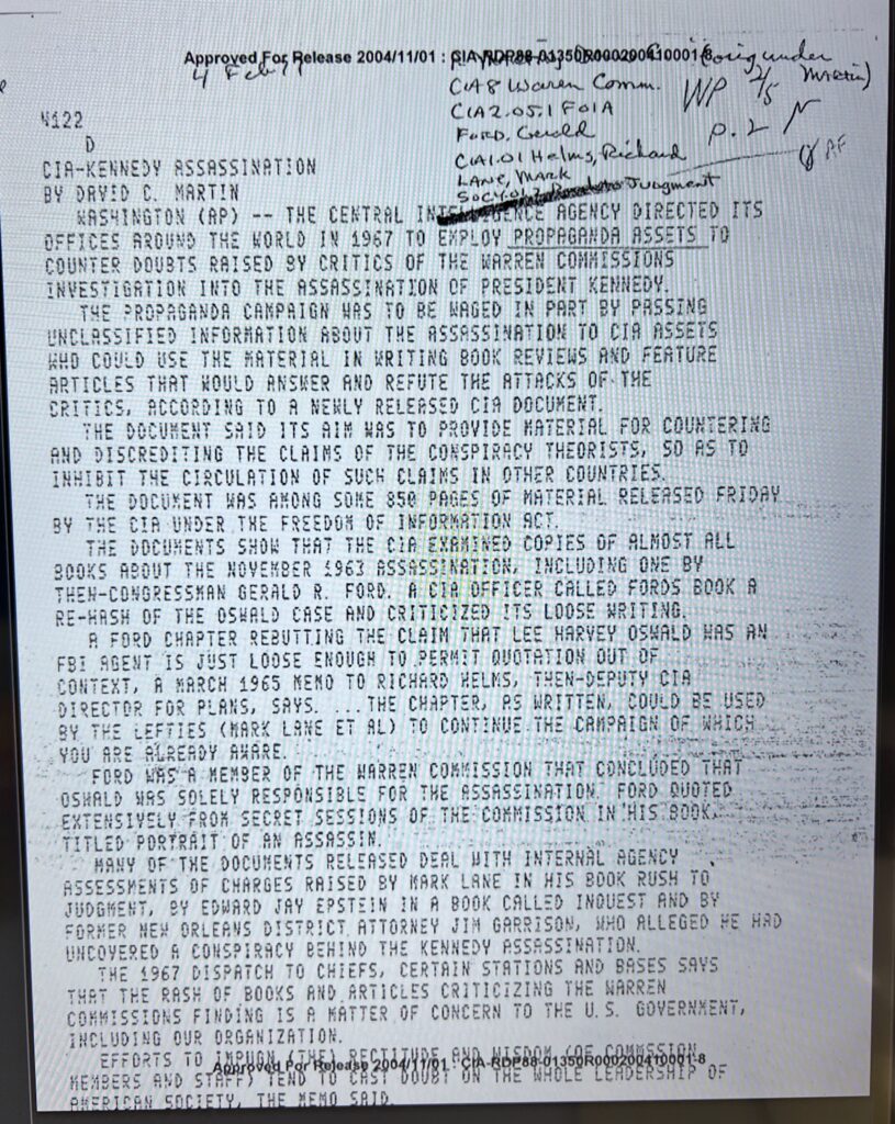
CIA-KENNEDY ASSASSINATION CoA8 Waren Coman WP MRRE)C(A2.05.1 F01A FoRD, Gercld CAL.O1 Helms, Rechand LANE, MARK P.2M BY DAVID C. MARTIN Socyts Jugment WASHINGTON (AP) — THE CENTRAL INTELGENCE AGENCY DIRECTED ITS OFFICES AROUND THE WORLD IN 1967 TO EMPLOY PROPAGANDA ASSETS TO COUNTER DOUBTS RAISED BY CRITICS OF THE WARREN COMMISSIONS INVESTIGATION INTO THE ASSASSINATION OF PRESIDENT KENNEDY THE PROPAGANDA CAMPAIGN WAS TO BE WAGED IN PART BY PASSING UNCLASSIFIED INFORMATION ABOUT THE ASSASSINATION TO CIA ASSETS WHD COULD USE THE MATERIAL IN WRITING BOOK REVIEWS AND FEATURE ARTICLES THAT HOULD ANSWER AND REFUTE THE ATTACKS OF-THE CRITICS, ACCORDING TO A NEWLY RELEASED CIA DOCUMENT. THE DOCUMENT SAID ITS AIM WAS TO PROVIDE MATERIAL FOR COUNTERING AND DISCREDITING THE CLAINS OF THE CONSPIRACY THEORISTS, SO AS TO INHIBIT THE CIRCULATION OF SUCH CLAIMS IN OTHER COUNTRIES. THE DOCUMENT WAS AMONG SOME 850 PAGES OF MATERIAL RELEASED FRIDAY BY THE CIA UNDER THE FREEDON OF INFORMATION ACT THE DOCUMENTS SHOW THAT THE CIA EXAMINED COPIES OF ALMOST ALL BOOKS ABOUT THE NOVEMBER 1963 ASSASSINATION, INCLUDING ONE BY THEN-CONGRESSMAN GERALD R. FORD. A CIA OFFICER CALLED FORDS BOOK A RE-HASH OF THE OSWALD CASE AND CRITICIZED ITS LOOSE WRITING. A FORD CHAPTER REBUTTING THE CLAIM THAT LEE HARVEY OSWALD FBI AGENT IS JUST LOOSE ENOUGH TO PERMIT QUOTATION OUT OF WAS AN CONTEXT, A MARCH 1965 MEND TO RICHARD HELNS, THEN-DEPUTY CIA DIRECTOR FOR PLANS, SAYS..THE CHAPTER, AS WRITTEN, COULD BE USED BY THE LEFTIES CMARK LANE ET AL) TO CONTINUE THE CAMPAIGN OF WHICH YOU ARE ALREADY AWARE. FORD WAS A MEMBER OF THE WARREN COMMISSION THAT CONCLUDED THAT OSHALD WAS SOLELY RESPONSIBLE FOR THE ASSASSINATION FORD QUOTED EXTENSIVELY FROM SECRET SESSIONS OF THE COMMISSION IN CHIS BOOК TITLED PORTRAIT OF AN ASSASSIN. MANY OF THE DOCUMENTS RELEASED DEAL WITH INTERNAL AGENC ASSESSMENTS OF CHARGES RAISED BY MARK LANE IN HIS BOOK RUSH TO JUDGMENT, BY EDWARD JAY EPSTEIN IN A BOOK CALLED INOUEST AND BY FORMER NEW ORLEANS DISTRICT, ATTORNEY JIM GARRISON, MHD ALLEGED HE HAD UNCOVERED A CONSPIRACY BEHIND THE KENNEDY ASSASSINATION. THE 1967 DISPATCH TO CHIEFS, CERTAIN STATIONS AND BASES SAYS THAT THE RASH OF BOOKS AND ARTICLES CRITICIZING THE WARREN COMMISSIONS FINDING IS A MATTER OF CONCERN TO THE U. S. GOVERNMENT, INCLUDING OUR ORGANIZATION. EFFORTS TO IMPUGN LTHEI RECTITUDE, AND MISDON COE COMMSSIUN Approved For Release 2004/11/01:CIA-RDP88-01350R000200410001-8 MEMBERS AND STAFF) TEND TO CAST DOUBT ON THE WAOLE LEADERSHIP 0F AMERICAN SDCIETY, THE MENO SAID
The Council of Scholars, via their digital enforcement arm, Wikipedia, has attempted to fence off one of the most powerful words in the human vocabulary: Auditor.
If you go to Wikipedia, they will tell you that an auditor is a “person or firm appointed by a company” who must be “certified by a regulatory authority.” They have turned a sacred human function into a bureaucratic desk job. They have moved the “Audit” from the town square to the boardroom, ensuring that only “authorized” voices are allowed to check the math of the elite.
1. The Etymological Theft: From “To Hear” to “To Obey”
The word Auditor comes from the Latin audire, meaning “to hear.”
The Original Function: In ancient civilizations—from Mesopotamia to the Roman Empire—an auditor was a Listener. Accounts were read aloud in public. The auditor was the person who sat, listened, and verified that the spoken word matched the physical reality.
The High-Bandwidth Ear: An auditor was a witness. They were the “Ear of the People.”
The Council’s Rewrite: The Council has replaced “Listening” with “Compliance.” They have redefined the auditor as a person who looks at paper provided by the offender and checks if it follows rules written by the Council. This isn’t an audit; it’s a Validation Loop.
2. The Professional vs. The Sovereign Auditor
Wikipedia splits auditors into “External” and “Internal,” both of whom are paid by the very systems they are supposed to be checking. They completely ignore the most important category: The Sovereign Auditor.
The Professional Auditor: A creature of the Administrative Rat King. They operate on “Agreed-upon procedures.” They are “independent” only in the sense that they aren’t on the direct payroll, yet their “Economic Benefit” depends entirely on maintaining a good relationship with the Council.
The Sovereign Auditor (You): This is the person who uses their own eyes, their own ears, and their own logic to “Audit” the world. Whether it’s a First Amendment auditor filming a police station, or a whistleblower auditing 58 pages of corporate gaslighting, the Sovereign Auditor is the only one truly capable of Independence.
3. The “Certification” Trap
Wikipedia claims you must “possess certain specified qualifications” to be an auditor. This is the ultimate gatekeeping tactic.
By requiring a “Certificate of Practice” from a “Regulatory Authority,” the Council ensures that any auditor who finds a “Signal” they don’t like can have their “Authority” stripped away.
It is a system designed to produce Silenced Experts.
4. Conclusion: The Audit is Yours
We reject the Wikipedia definition. On Signal vs. Noise, an Auditor is anyone who refuses to accept the “Official Narrative” without checking the math. An Auditor is a person who listens to the noise of the Council and extracts the Signal of the Truth.
You do not need an appointment. You do not need a certification. You do not need the Council’s permission to hear the truth.
Notice the first sentence of Hancock’s entry: “British author known for promoting pseudoscientific explanations…”
The Forensic Tactic: Within the first ten words, the Council has placed a “bio-hazard” sticker on the man. They don’t address the Forensic Anomalies of the Sphinx or the Younger Dryas; they attack the category of his work.
The “Culture Hero” Mockery: The entry mocks his challenge to academic dogmatism, framing a pursuit of spiritual understanding as “paranormal mythic narrative.” They use the word “mimicking” to describe his journalism, a direct attempt to invalidate his professional background in favor of Council-approved “Scholars.”
II. Neil deGrasse Tyson: The “Apostle of Materialism”
The Forensic Tactic: Every sentence is anchored in Institutional Authority (Harvard, Princeton, NASA). He is framed as the “Science Communicator”—the authorized broadcaster for the Council.
The Hidden Agenda: Tyson is the primary salesman for Materialist Determinism. He is promoted because he tells the public that they are “stardust” in a meaningless void, effectively stripping them of the agency required to challenge the Global Grid.
III. Robert Sapolsky: The “Biological Slave Driver”
Sapolsky’s entry is clinical, professional, and dense with titles: “Professor of biology, neurology, and neurosurgery.”
The Forensic Tactic: By presenting Sapolsky as the ultimate authority on “stress” and “primatology,” the Council prepares you to accept his most dangerous thesis: that you do not have Free Will.
The Intellectual Enclosure: While Hancock is “dismissed” for suggesting humans have untapped potential, Sapolsky is “promoted” for suggesting we are biological machines with no choice.
Conclusion: The Council’s Selective Reality
The disparity is clear. Wikipedia is designed to protect The Intellectual Slave Drivers.
If you tell people they are powerful, ancient, and connected to a Global Grid (Hancock), you are labeled a Fraud.
If you tell people they are cosmic accidents with no free will (Tyson/Sapolsky), you are labeled an Expert.
The Audit of Wikipedia reveals that the Council isn’t interested in “Facts”; they are interested in Compliance. They give “Laurels” to those who keep the cage locked and “Labels” to those who find the key.
The “Guilt” Filter: Consensus as a Weapon of Compliance
In the final layer of the Council’s broadcast, we find the “Scientific Communicator” shifting from astrophysics to moral policing. In a revealing clip, Neil deGrasse Tyson asserts that “Consensus is Truth” and that the current climate shift is purely a result of individual human conduct.
I. The Selective Silence of the .01%
Tyson is an incredibly intelligent man. He operates in the highest circles of power and institutional funding. He is undoubtedly aware of the following high-bandwidth realities:
Despite his role as a “Science Communicator,” Tyson has never once used his platform to audit these programs. He never discusses the massive, industrial-scale engineering projects currently attempting to “hack” the climate from the top down.
The Attack: He labels those who notice anomalies as “deniers” or “unscientific.”
The Reversal: He reverses the roles of victim and offender. He takes the environmental impact of the military-industrial complex and the global elite and places the “sin” on the collective consciousness of the average person driving a gas-powered car to work.
III. The Goal: Learned Guilt
When Tyson says “Consensus is Truth,” he is telling you that the “Council” has voted on reality, and your personal observations are no longer valid. This is designed to create a state of Learned Guilt. A guilty population is a compliant population. If you believe you are responsible for the destruction of the planet, you are far more likely to “follow orders,” pay the “Carbon Taxes” of the future, and accept the “Administrative Rat King’s” control over your movements.
Audit Conclusion: The False Prophet of the Void
Tyson’s Wikipedia entry calls him a “public welfare” hero. The Audit reveals him as an Intellectual Border Guard. He stands at the edge of the “Cage,” pointing at the stars to keep you from looking at the machines in the atmosphere, and pointing at your car to keep you from looking at the people who actually run the world.
Wikipedia markets itself as “The Free Encyclopedia,” but in the Audit, we recognize it as the Enforcement Arm of the Council of Scholars. By using a “Consensus” model, they ensure that the “Signal” is always drowned out by the “Noise” of the status quo.
In this section, we deconstruct how Wikipedia uses Ad Hominem attacks, selective labeling, and “Authority Anchoring” to tell you who to trust before you ever read a single fact. We are moving beyond the curated entries and looking at the Forensic Bias that powers the machine.
The Council of Scholars has spent the last century turning History into a sedative. They have transformed the most explosive, terrifying, and awe-inspiring events in human memory into a dry recitation of dates and “societal shifts.” They want you to believe that the past was a slow, boring crawl of “primitive” people toward our current “peak.”
They are lying.
History is not a textbook; it is a Signal. It is the record of a high-stakes, planetary drama featuring gods, tyrants, geniuses, and survivors. It is the story of how we built the Global Grid, how we lost it, and how we have been trying to “re-boot” the system ever since.
Our Guide: Herodotus, The First Auditor
To navigate this terrain, we are bringing back the original whistleblower: Herodotus.
The Council calls him the “Father of Lies” because he dared to record the stories they couldn’t explain. He traveled the known world, asking the questions the experts were too afraid to ask. He didn’t just record the wars; he recorded the customs, the anomalies, and the “miracles.” He understood that to know where we are going, we have to look at the Forensic Anomalies of where we’ve been.
What You Will Find Inside the Audit
This section is designed to replace the sanitized Wikipedia narrative with the Unfiltered High-Bandwidth Stream of our species.
The War of the Worlds: Forget the “diplomatic causes” of the Greco-Persian Wars. We look at the existential clash between the Slave-State “Imperial Toil” of Persia and the “Resonant Freedom” of the Greeks.
The Egyptian Enigma: We return to the source. Herodotus saw an Egypt that was already ancient, already full of machines and monuments that defied his own timeline.
The Lost Civilizations: We track the “Ghost Cultures” that the Council has deleted—the people who built the megaliths and mapped the stars before the “Great Reset.”
The “Mythic” Truths: Giant gold-digging ants? Flying serpents? We don’t dismiss these as “folklore.” In the Audit, we ask: What was the physical reality that generated this report?
The Competition: Why Wikipedia Fails
Wikipedia is a “Neutral Point of View” (NPOV) cemetery. It refuses to speculate, refuses to connect the dots, and refuses to admit that the “Official Narrative” is crumbling.
Signal vs. Noise does not do “neutral.” We do Truth. We provide the granularity and the passion that the Council’s curriculum has surgically removed. This is history written by the people who lived it, for the people who refuse to be forgotten.